Overview MSc Research Topics

3D models such as Building information models (BIM) are valuable for industry for various planning purposes.

Unmanned Aerial Vehicles (UAVs) are increasingly used within an Internet of Things (IoT) network where the UAV can communica

Protected areas are useful governance tool to mitigate biodiversity loss and preserve threatened habitats and species.

Global production, transportation, and consumption of oil can cause inevitable spills into the environment (typically from pipelines, oil wells, and storage facilities) cont

Accurate measurements of solar irradiance (incoming sunlight) and radiance (light coming from a specific direction) are fundamental in Earth Observation (EO).

The rapid pace of urbanization underscores the need for stakeholders in sustainable development to view cities and their surrounding regions as interconnected systems rather than

This MSc topic develops a typology of Dutch regions that captures how remote work affects their spatial, economic and social characteristics (Extending Task 2.3 of R-Map1).

Grid-based travel friction grids represent travel cost for moving through each cell of a landscape, enabling flexible and spatially detailed travel-time calculations.

Generative AI and Digital Twins (DTs) are redefining how urban environments are conceptualized, designed, and managed.
For years, MODIS images have been instrumental in divers environmental and ecological studies such as monitoring deforestation, land-us/land-cover (LULC) changes, agriculture and epidemiology.

Green spaces are fundamental for the well-being of individuals and communities as they provide areas for recreation, which is essential for the quality of life in cities.

Urban slums are among the most vulnerable environments in terms of food access, dietary adequacy, and livelihood stability.

Natural hazards increasingly occur not as isolated events but as multiple, interacting phenomena (e.g., earthquakes followed by landslides, or compound flooding driven by storm surge and extreme ra

This study aims to investigate the environmental impacts of armed conflict in West Darfur, Sudan, with a particular focus on vegetation dynamics.

The decisions made on the spatial configurations and distributions in the built environments (urban or rural developments) directly affect the environment as well as the interests of various actors

3D models such as Building information models (BIM) are valuable for industry for various planning purposes.
Generative AI software development tools like Bolt.new enable the fast, efficient, and easy build of all kinds of web services and platforms.

Rainfall data series from climate models (i.e.

One of the greatest challenges in scientific research is bridging the gap of technical knowledge and practical solutions for communties.

Tropical lowland rainforests in Sumatra have been extensively degraded through logging and conversion to oil palm plantations, resulting in major ecological and biophysical chang

Northern Kenya’s dryland ecosystems are socio-ecologically complex landscapes where vegetation, water availability and livestock mobility interact to support pastoral livelihoods.

The Antarctic ice sheet covers almost the whole area of the Antarctic continent. It is the largest ice mass on Earth, with an average ice thickness of about 2 kilometers [1].

Interest in the formal representation of citizen science comes from portals, platforms, and catalogues of citizen science projects; scientists using citizen science data for their research; and fun

Sentinel-1, with a constellation of radar satellites, operates day and night, providing freely accessible, consistent, and time series SAR images of every part of the Earth.

This study examines soil health as a key indicator of rangeland restoration success in the semi-arid ecosystems of Samburu County.
LAI is one of the most critical vegetation biophysical variables as well as remote sensing- enabled essential biodiversity variables due to the controlling role of green leaves in biological and ph

In many rapidly growing cities across Sub-Saharan Africa, residents – especially those living in informal settlements – face multiple challenges from limited access to safe and r
More and more cities are developing digital twins of their critical public infrastructures.

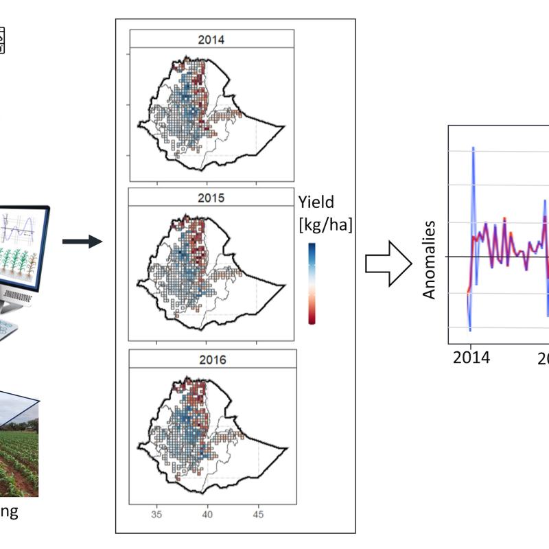
Ethiopia’s diverse agricultural landscape is crucial to its economy and food security.

This research focuses on mapping crop residues in Ethiopia using UAV (Unmanned Aerial Vehicle) and satellite imagery.

Based on research and consultation, a prototype of a project dashboard for healthcare will be developed and tested.

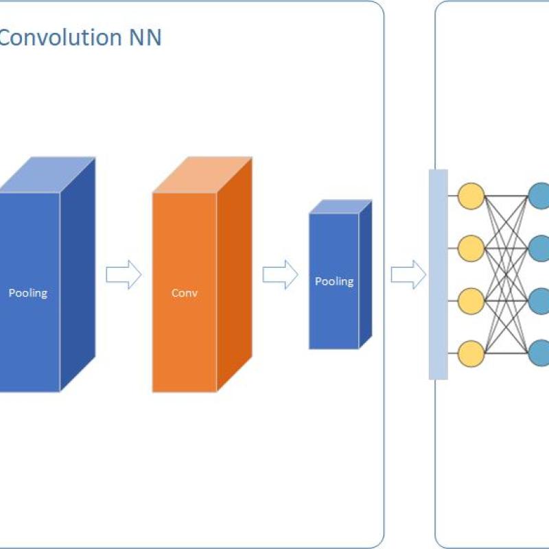
Object detection is a fundamental topic in computer vision. Recently, deep learning has become an effective method and achieved great success in object detection.

The presence of noises, clouds and another atmospheric phenomena represent an obstacle for optical remote sensing applications.

Brazil is the biggest coffee productors in the world, with millions of hectares of plantations.

Estimating aboveground biomass is essential for generating vegetation inventories and understanding carbon cycles.

An accurate method for automatically mapping deforested areas constitute an important tool to inform and enable deforestation containment policies.
Aboveground forest biomass has fundamental role in carbon cycling, climate processes, and global warming.

The climate in cities and metropolitan areas (i.e., urban climate) is often different from the climate in the surrounding rural areas due to the presence of buildings, pavement, a
Mapping and monitoring slums is essential to ensure the sustainable development of the cities to ensure a quality of life for people.
To model air pollution in urban environments while accounting for urban forms using convolutional neural networks (CNN) or Vision Transformers (ViT), open access earth observation

The problem of 3D spatial perception involves the real-time construction and maintenance of a comprehensive and actionable representation of the environment using sensor data and prior knowledge.

Downward-looking satellite sensors are used to display our three-dimensional (3D) world with 2D remote sensing imagery.
Deep Neural Networks (DNN) is considered as a panacea for different problems in several application areas. But what about spatial modeling?

Visual Simultaneous Localisation And Mapping (SLAM) has been one of the most relevant research topics in robotics for the last two decades.

The student will initially revise the existing literature on image matching algorithms using CNN as backbone.

The goal of this study is to detect and map bark beetle infestation in a temperate forest in Germany using DESIS hyperspectral satellite data.

The goal of this study, as part of the larger BIOSPACE project, is to map and model foliar pigments, including chlorophyll and carotenoids and thei

Forest health worldwide is under pressure as a result of prolonged droughts.

In recent years, the Greater Horn of Africa has suffered from prolonged droughts, associated with forced migration and food and water security issues.
The challenge of this topic is to detect a change or trend on top of seasonal fluctuations.

Vietnam is one of the most disaster-prone countries in Southeast Asia, facing increasing pressure from natural hazards.

ITC research staff from the GIP, PGM and NRS departments, in collaboration with CRIB have developed global maps that estimate land-based trave

Clouds usually represent a big problem for optical remote sensing. A wide range of works have been developed in producing efficient cloud detection algorithms.

Digital Twins (DTs) are rapidly becoming one of the most exciting innovations in smart cities, bringing together 3D modelling, geospatial data, IoT sensors, and AI t

Nepal is highly vulnerable to natural hazards such as earthquakes, landslide and floods.

Urban systems consist of multiple interrelated components, including physical and social structures, among them people, organizations,

Drought has wreaked havoc to human societies throughout history. Drought is usually caused by a multitude of factors starting from the deficit of precipitation when compared to climatic mean.
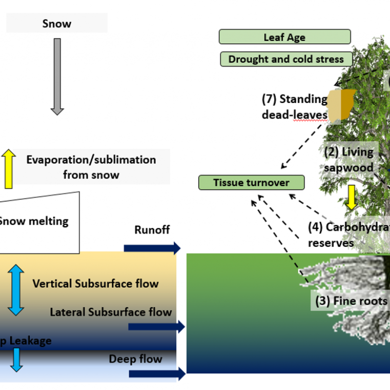
ET is the water lost to the atmosphere through plant stomata during photosynthesis and from the surface following a we
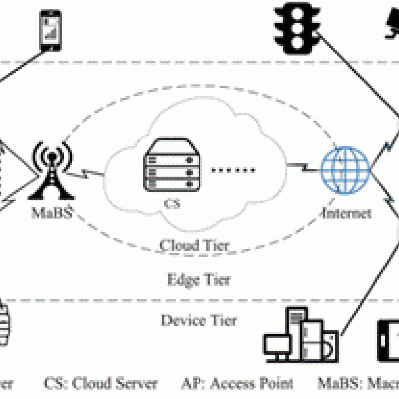
Unmanned Aerial Vehicles (UAVs) are increasingly used within a Mobile Edge Computation (MEC) network where the UAV is made intelligent by equipping it wit
Understanding the types of vegetation that composes the land cover on non-anthropic areas and the land use for anthropic areas is essential to understand ecosystems dynamic

Unsafe houses and natural hazards are increasingly common threats for citizens of low-income countries.


The past decades have seen rapid advancements in space-based monitoring of essential water cycle variables, providing products related to precipitation, evapotranspiration, and so

Anticipatory actions (AAs) are pre-emptive measures taken to mitigate the impacts of disasters based on forecasted hazards.

Mediterranean and temperate forests are being affected by intense and frequent droughts that will become more frequent and s
Urban environmental planning and management, both in theory and practice, have indicated the need for participatory inclusivity as much as possible.

Biodiversity loss is one of the main challenges that our society faces today and the current loss of biodiversity caused by human actions is referred to as the

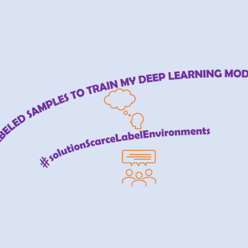
In many parts of the world, agricultural monitoring is hindered by limited field data, inconsistent surveys, and highly heterogeneous landscapes.
Thermal remote sensing is a type of passive remote sensing since that detects naturally emitted radiation. Most thermal remote sensing for vegetation conducted in the 8-14 μm wavelengths.

Unmanned Aerial Vehicles (UAVs) are increasingly used by public and private organizations such as the Politie, Brandweer or Rijkswaterstaat.

UN-Habitat estimates that over one billion people around the world live in slums, which are often located in hazard-prone areas.
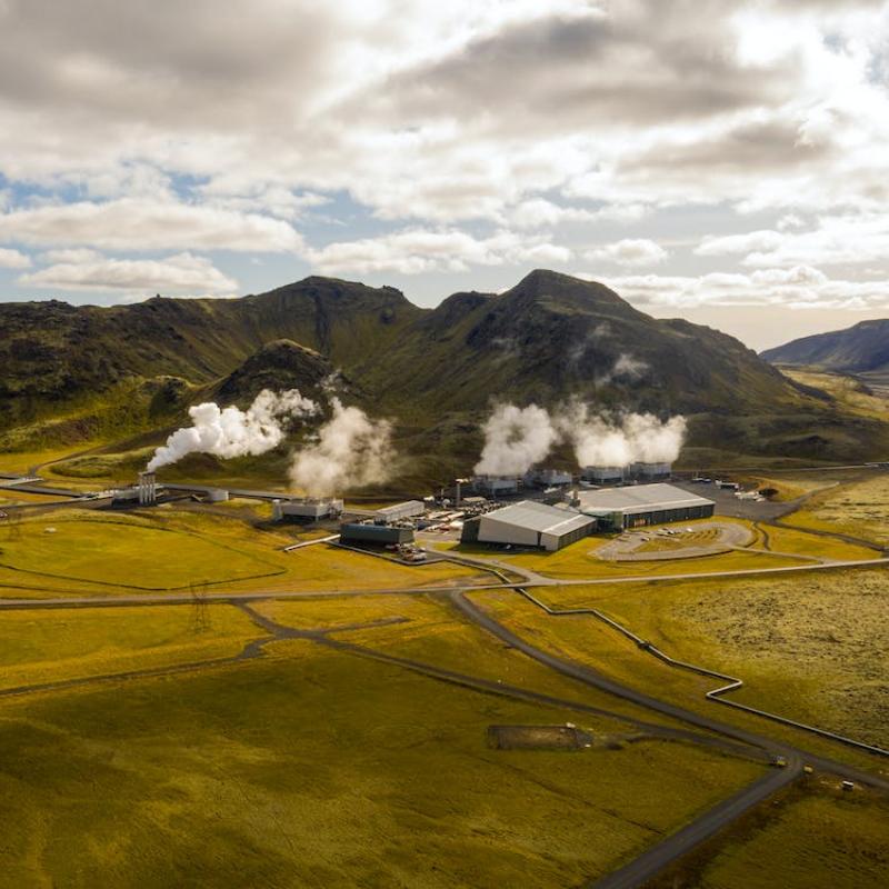
Geothermal systems are one of the sustainable sources of our future energy mix.
The phenomenon of urban heat islands generally refers to the heating of urban areas compared to their undeveloped surroundings.


Forest health worldwide is increasingly deteriorated by droughts.
With down-looking satellite sensors, our three-dimensional (3D) world is commonly represented with 2D remote sensing images.

Beavers are often referred to as “ecosystem engineers” because their dam-building activity reshapes river corridors, alters local hydrology, and creates mosaics of ponds, wetland
Water resource management needs to consider a wide range of spatial scales and address a variety of problems, e.g.

Training a geospatial AI model is like setting up a game—the rules you choose for sampling data determine who wins and who loses.

Deep learning algorithms can achieve great accuracies, but there are also concerns about biases and generalizability to unseen data.

Generative AI has been used in many applications such as text generation and image generation such as (chatgpt, dall-e etc.) but can they generate realistic hazard scenario

Unmanned Aerial Vehicles (UAVs) are powerful flexible monitoring devices, and their data is increasingly used to train deep

Generative Design is an umbrella term for a variety of approaches to the derivation of topological-geometric configurations directly from the design requirements and goals in a feedforward process

Global prediction of anemia, stunting, and wasting using household surveys and geospatial covariates
This MSc project aims to generate high-resolution global maps of anemia, stunting, and wasting by combining biomarker and anthropometric data from DHS/MICS with globally consistent environmental, a
Access to safe drinking water, sanitation and hygiene (WASH) services and associated health benefits are widely enjoyed in high-income countries , where centuries of investment in infrastruct

Heat hazard, in the form of heat waves principally affecting larger urban areas, has evolved into one of the most deadly hazard types, especially in the Global North that tends to se
The current trend of COVID-19 epidemic threatens to decimate populations even in advance countries.

Timely and accurate data on the extent of croplands and the types of cultivated crops are essential to addressing the food insecurity challenges that many African countries face.

Climate change leads to a increased frequency of extreme precipitation and prolonged drought period, both of which have a severe impact on the landslide initiation as they
Deep learning algorithms have gained increasing popularity in remote sensing due to their accuracy.

Individuals and the organisations in which they work need to cooperate in projects and research to withstand an increasing competition.

In close collaboration with colleagues from the University of Kwazulu Natal, we can offer a series of MSc research topics related to humanitarian and urban development related to

Understanding of the effect of climate change on ecosystems is of great importance.

This thesis topic want to explore how the design of public spaces can facilitate social interaction, and how ICTs can be used to inform this design.

Identifying Socio-Spatial Potentials to Improve Liveability Using Street Network Centrality Analysis
In a time when wicked problems, such as biodiversity loss, climate breakdown, the housing crisis, and eroding social solidarity, are escalating, it is becoming increasingly impor

Improved quality of life is one of the New Urban Agenda (NUA) underlined sectors to be incorporated "in every urban development or renewal policy and strategy" (UN-Habitat, 2017).

Indoor scene understanding is important for tasks like indoor navigation and semantic mapping.

The arid and semi-arid lands (ASALs) of northern Kenya face pressing challenges due to climate change, environmental degradation, and socio-economic vulner
Natural hazards such as earthquakes, floods, and landslides pose a persistent threat to the built environment, causing large economic losses and loss of life worldwide.

In the realm of artificial intelligence (AI), the advancement of large language models (LLM) like GPT-4, the base model of ChatGPT, has revolutionized natural language processing.

The estimation of canopy height, AGB and its changes is typically carried out using active Remote Sensing data such as LIDAR or Interferometric Synthetic Aperture Radars (InSAR)

Impervious surfaces are the Earth’s surfaces covered with mainly anthropogenic and artificial structures, such as built-up areas, roads and streets, and parking lots.
This project is part of a 2 year EU MSCA project.

A workflow is considered to be a combination of data and (software) operations.
Climate change and migration are understood to have a complex relationship.

Mediterranean thermophilous pines, which are the key, dominant, and characteristic species of this habitat, form some of the most drought-resilient woodlands in Europe.

Urban slum is often vulnerable to environmental changes such as subsidence, as it has densely populated informal settlements

Labelling point clouds is tedious work.

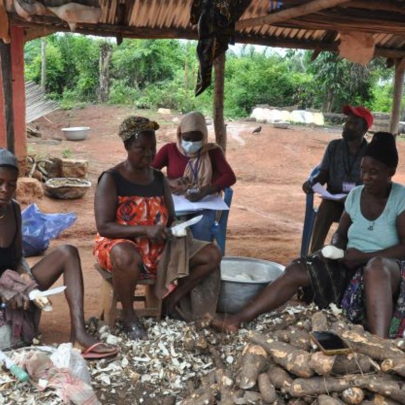
Sufficient nutrition remains a major challenge for rural households in the Sub-saharan region of Africa.

The arid and semi-arid Lands (ASALs) of northern Kenya are characterized by extremes of poverty and climate.

Crop nutrient concentrations result from the interactions between soil fertility, plant nutrient uptake, and crop growth.

As a result of hardware miniaturization and ubiquitous internet access, there is a wealth of user- and sensor-generated geographic content available, from social media activity to private weather s
Being freely available, weather- and sunlight-independent, Copernicus Sentinel-1 data are increasingly being used for a variety of remote sensing applications.
Information on the spatial distribution of crops is of great importance for the sustainable management and development of agricultural practices and thus for national and global economic developmen
Humanitarian organizations such as the Red Cross Red Crecent and Unicef use risk models to identify vulnerable populations and mitigate the affects of natural disasters.

Accurate and reliable data is demanded in water, climate and environmental studies but such data cannot be guaranteed in many countries as observation networks have deteriorated.

Utilities form the essential infrastructure of a contemporary society, fulfilling fundamental requirements for both residents and industries.

Aflatoxin contamination in grains is a significant health risk to humans and livestock as it causes human cancer, liver cirrhosis, stunting in children, and death.

Fires are a common phenomenon during the dry season in southern Africa, as lightning strikes ignite dry vegetation, farmers burn crop residue, and hunters light light fires to flu

Recently, mortality and reduction in forest stand densities for Brutia pine (Pinus brutia) have been found ov

The Brazilian cerrado biome is under pressure, as an increasing part of it is converted to agriculture.

Crop mapping plays an important role in agronomic planning and management both for farmers and policymakers. Satellite remote sensing sensors have become efficient tools for mapping croplands.

In the base registry of the Dutch topographic maps (BRT, map scale 1:10.000), relief elements are objects that represent height differences in the landscape. Examples of rel

The rate of carbon uptake by vegetation is not fully known.

Measurement of the effect of regreening efforts can be done by using an index for the amount of green vegetation, and a measure of recovery.
Food insecurity is a big issue in eastern and southern Africa and projections are that this is going to get worse with climate change and variability.

Forests are among the most diverse ecosystems on our planet.

LINK TO RESEARCH PROJECTS
The MSc topics link to several ongoing larger research projects that allow being part of international research teams - both projects just started:

Mapping the presence or abundance of an animal or plant species is a non-trivial challenge. It often involves elaborate field surveys with strict data collection protocols and usually deep un

Monitoring forest dynamics is essential for identifying the area most at risk for forest degradation and deforestation, and

Coral reefs are vital ecosystems that provide ecological, economic, and cultural benefits—but they are under growing pressure from land-use change and marine tourism.

A wide range of topics are available (See below).
Land use classification of urban area is one of the most important applications of remote sensing images. Urban management is generally in demand to account the dynamics of land uses.

In order to be able to design appropriate risk reduction measures to reduce the increasing impact of multi-hazard events, it is important to have tools to estimate the losses of these compounding e
RGB cameras are inexpensive, lightweight sensors that provide information-dense data for various tasks, such as localisation, 3D reconstruction, and scene understanding.

Understanding how crops and grasslands respond to drought and weather extremes requires observations at multiple scales.
Objective
To develop a deep learning model to estimate the timing of phenological events over large area

“Nature-based solutions” (NBS) or “building with nature” have received global attention as a multidimensional approach to reduce impacts of climate change and associated meteorological disaster ris
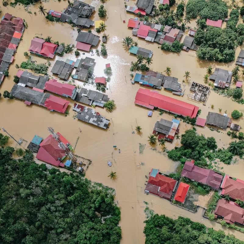
South-Limburg suffers from plvial floods ad flash floods occasionally. The last floods in 2021 caused immense damage in the river Geul.

This topic is suitable for those with an interest in Disaster Risk Management, human behavior, and decision-making.

Neural Radiance Field (NeRF) stands as a category of neural networks adept at represent and render realistic 3D scenes environments using a set of 2D images.

Spatial autocorrelation is a property of any dataset that is linked to locations. So both raster and vector data have this property.
Behind the many different data sources available to innovate geospatial technologies and methodologies are large data infrastructures needed to produce and process geospatial data.

Human onchocerciasis (river blindness) is part of the so-called Neglected Tropical Diseases (NTDs) that jointly affect more than one billion people living in impoverished communit

Advances in AI enable new approaches to solve existing problems, but they also create new challenges especially concerning the veracity and validity of digital content.

Are you passionate about shaping the future of remote sensing?

Urban heat stress is one of the most pressing climate risks in the Netherlands, with strong impacts on public health, infrastructure, and energy demand.

Optimal performance of computations is one important promise that databases make to their user community.

So far, more than 6.5 million people have died from COVID-19, and still, there are around 1000 deaths per day.
Climate change is a reality, and thousands of scientists have declared that we are living in a climate emergency.

Food packaging is responsible for 5.4% of global food systems emissions in 2015 (Crippa et al., 2021).

Remote work is reshaping where people live, work and travel, with uneven impacts across the urban–rural continuum.

Nowdays, wildfire is one of the most important environmental problems in the world, affecting a wide range

As an essential part of food security, diet diversity often requires frequent household food security surveys to monitor.

Farmers, agronomists, private enterprise and policy-makers need to know field conditions with sufficient early-warning.

In cities, temperatures are often higher than in the surrounding areas and can also vary locally.

As a result of hardware miniaturization and ubiquitous internet access, there is a wealth of user- and sensor-generated geographic content available, from social media activity to private weather s

The goal of this study, as part of the larger BIOSPACE project, is to map and model leaf and canopy nitrogen content and their spatial variations in a bor

The goal of this study, as part of the larger BIOSPACE project, is to map and model Specific Leaf Area (SLA) and its spatial variation in a boreal forest

New and affordable sensors (e.g., Arduino Nano 33 BLE Sense, Sensebox) have greatly increased the potential to collect finer-grained environmental information, especially on topics impacting on hum

Recent research has shown that, in European cities, the quality of adaptation planning has improved over the last approximately 15 years; however, the focus on justice and vulnerability in climate
The concept of nature conservation as well as ecosystem sustainability has received substantial attention of the human society, such is even more so recently given the dire IPCC warning about the a
Many land administration and spatial planning organizations are undergoing processes of digitalization of their spatial data holdings, communication networks, and work flows.
Unmanned Aerial Vehicles (UAVs) provide excellent opportunities for more efficient and detailed infrastructure monitoring.

This project aims to explore using monocular cameras in the real-time construction of 3D scene graphs in outdoor applications.

3D reconstruction using stereopairs is still an open research topic in different communities, such as computer vision, research and remote sensing.

The estimation of depth from a single image have been a Computer Vision topic for decades.

Many mineral assemblages that are interesting for providing raw materials for the energy transition (lithium, rare earth minerals) cannot be detected by multi-spectra

In the past couple of years, Neural Radiance Fields (NeRF) [1] and methods derived from it have become a popular choice for solving different tasks such as novel view

HANPP estimates the actual biomass production (Net Primary Productivity or NPP) following anthropogenic intervention.

Remote work is transforming mobility needs in knowledge regions such as Twente, where universities and high-tech firms attract workers and students from both the Netherlands and

About 75% of the Earth’s land surface has been altered and land use change has affected more than 30% of global

Unmanned Aerial Vehicles (UAVs) have found significant applications in road monitoring, offering a versatile and efficient solution for infrastructure assessment and

In many countries, shortage of drinking water is a problem.

Synthetic-aperture radar (SAR) data from Sentinel-1 satellites provides unprecedented opportunity to evaluate inter-annual flood characteristics, although consen

This study aims to assess the applicability of satellite rainfall estimates (SRE) in crop growth modelling by means of the Aquacrop model.
Data acquired from indoor environments contains a lot of valuable information about the assets and facilities.

To inform policymakers about the agricultural landscapes and food production, accurate and timely monitoring of crop type is required.

Primary production is the growth or accumulated rate of biomass in plants.

Mapping slums in different urban environments across the Globe is extremely important for locating and prioritizing hotspots of urban poor for urgent climate action to combat the impact of cl

The current trend of COVID-19 epidemic threatens to decimate populations even in advance countries.

This is a broad thesis topic that aims to develop additional data to support the characterizatio

The mechanism by which we observe a phenomenon that unfolds in space and time fundamentally determines what we can learn about that phenomenon.

Food packaging is responsible for 5.4% of global food systems emissions in 2015 (Crippa et al., 2021).

Understanding how soil moisture and groundwater systems respond to climate variability and extreme weather is crucial for drought management, water resources planning, and climat

The accurate prediction of crop yields is a critical element in ensuring global food security, managing agricultural markets and supporting the decision-making processes of farmers and

For a skyscraper to be stable, it must be built on a strong foundation. However, several factors such as persistent use, aging and deterioration, etc.
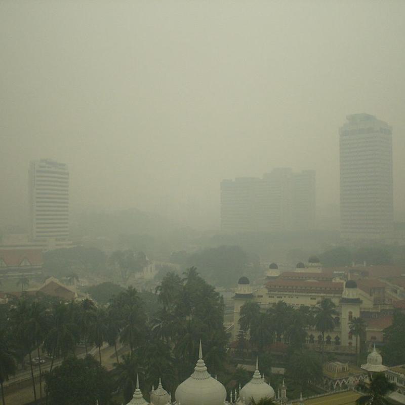
The growing public health concerns about ambient air quality such as particulate matter (PM) concentrations suggest the need for a holistic monitoring to guide interventions.

The new Surface Water and Ocean Topography (SWOT) satellite, launched in December 2022, aims to map Earth's water in unprecedented detail to help manage climate change and to shar

Geo-referenced time series are data describing the time-changing behavior of one or more attributes at fixed locations and consistent time intervals [1].
The goal of sustainable transport is to promote better and healthier ways for individuals and communities to meet their travel needs while reducing the negative social, environmental and economic i

Drones are increasingly used to create 2D and 3D maps to support monitoring and emergency scenarios.

A huge task is waiting to realize the global agenda in relation to tenure security as recognized by the sustainable development goals (SDGs) set by the UN.

Thermal remote sensing is a type of passive remote sensing that detects naturally emitted radiation.

Rocks and minerals do not change by day or by season. However, the environment in which remote sensing images are acquired changes continuously.

The world’s human population has been tripled during the past 70 years, from 2.5 billion in 1950 to 7.7 billion now (UN-Habitat).

Environmental noise has been associated with increasing blood pressure, heart disease, and sleep disturbance, among other complaints.

The livelihoods of many people in the East African drylands heavily depend on livestock.

Bark beetle outbreaks have transformed large areas of Central European spruce forests, including the Bavarian Forest National Park.

Monitoring the structure of Vegetation is one of the big applications in Remote sensing.

Environmental data is often rich and complex.

Vegetation is currently scarce on Greenland, and does not occur on the ice-sheet, as it grows around the edges.

Due to climate change, urban environments are becoming warmer. Residents may go to urban parks to cool off if their apartments are too hot (Wong et al., 2024).

Although large language models (LLM) have been around for a while, the public release of ChatGPT demonstrated a quantum leap in the abilities of these models to respond to natural

The economic and humanitarian impacts of tropical cyclones across the small island developing states (SIDS) in the Caribbean are very high; and greater than those of larger mainland cou

GLOFAS is an ensemble of 3 components: A Metrological Model and Forecast (Numerical Weather Prediction (NWP) forecasts of the ECMWF IFS), A hydrological model (LISFLOOD) and a web

Smallholder farming systems in Sub-Saharan Africa frequently involve intercropping, where multiple crops are grown together on the same parcel.

The fusion of UAV-based and satellite-based data has emerged as a powerful approach for plant health monitoring in agriculture.

Drones or UAVs are revolutionizing conservation and agricultural practices, offering cost-effective and safe methods for data collection over large, challe

Air pollution remains a critical public health challenge across Europe and globally.

When infrastructure companies refurbish asphalt, a road-marking inventory needs to be created in advance to allow for accurate road marking replacement.

How much could we know about cities by only inspecting their physical forms?

Droughts are exacerbated by climate change, which makes them more frequent, prolonged, and catastrophic.

Ecosystem structure exhibits sensitivity to climate change.

The concept of Essential Climate Variables (ECVs) has been established to serve as a key climate indicator that
The droughts of 2018-2020 in the Netherlands created great social distress, induced huge economic damages in agricultural production, disrupted river navigation and damaged buildi

The recent 2018-2020 drought events that occurred in the Netherlands were considered as extremes, creating great social and economic damage in agriculture production.


Population growth around volcanoes exposes millions of people worldwide to the risks of volcanic activity.

Climate change is nowadays prominently present on the political and thus scientific agenda, which is reflected in the Dutch Delta-Programme for Spatial Adaptation (“Delta-Programma Ruimtelijke Adap

Urban areas experience unique microclimatic conditions due to the alteration of land surface characteristics, increased impervious surfaces, and anthropogenic heat sources.

Interactive computational notebooks are browser-based tools that support shared workflows, coding, data, and visualisations.

Understanding the hydrologic and energy cycles to enhance our meteorological and hydrological monitoring capa

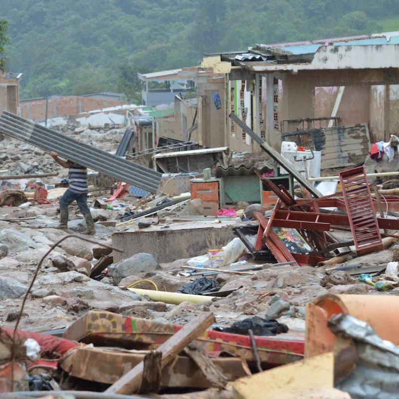
In September 2024, Storm Boris caused massive flooding across Central Europe, causing severe damage including the collapse of the Carolabrucke in River Elbe, Dresden, Germany.

Anticipatory actions (AA) are pre-emptive measures taken to reduce disaster impacts based on forecasted hazards.
On 6 February 2023 a magnitude 7.8 earthquake affected the border region between Türkiye and Syria, killing an estimated 55,000 people and causing damage to more than 4 mil

In urban environments, GPS-based positioning systems face significant challenges, including signal blockages, low satellite visibility, disconnections, and so caused mainly by dense building struct

To develop a model to estimate the timing of phenological events over large areas from time series of earth observation data using vision transformers, a fierce alternative to tra

Water level in lakes and rivers is a critical parameter to monitor for water managers. It captures the state of surface waters, and, if placed strategically, can be used in e.g.

Aside from flooding, agricultural areas in flat terrain suffer from seasonal water logging after excessive precipitation.

The majority of the Earth Observation missions focus on daytime monitoring.