GIMA MSc Research Topics

Global production, transportation, and consumption of oil can cause inevitable spills into the environment (typically from pipelines, oil wells, and storage facilities) cont

Generative AI and Digital Twins (DTs) are redefining how urban environments are conceptualized, designed, and managed.

Green spaces are fundamental for the well-being of individuals and communities as they provide areas for recreation, which is essential for the quality of life in cities.

The decisions made on the spatial configurations and distributions in the built environments (urban or rural developments) directly affect the environment as well as the interests of various actors

The Antarctic ice sheet covers almost the whole area of the Antarctic continent. It is the largest ice mass on Earth, with an average ice thickness of about 2 kilometers [1].

Interest in the formal representation of citizen science comes from portals, platforms, and catalogues of citizen science projects; scientists using citizen science data for their research; and fun
More and more cities are developing digital twins of their critical public infrastructures.

The climate in cities and metropolitan areas (i.e., urban climate) is often different from the climate in the surrounding rural areas due to the presence of buildings, pavement, a
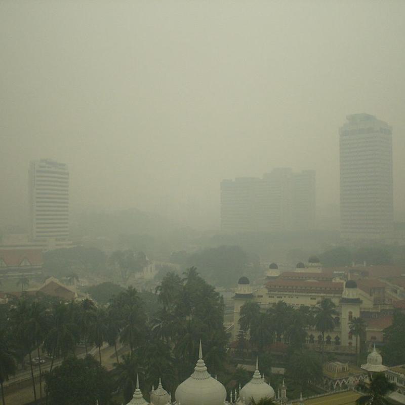
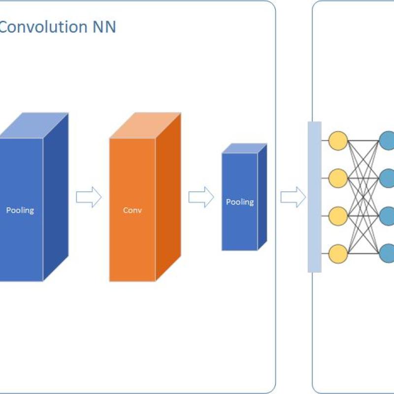
To model air pollution in urban environments while accounting for urban forms using convolutional neural networks (CNN) or Vision Transformers (ViT), open access earth observation
Deep Neural Networks (DNN) is considered as a panacea for different problems in several application areas. But what about spatial modeling?

As cities confront accelerating climate pressures, the ability to explore plausible spatial development trajectories, and test their performance against projected hazards, offers va

In recent years, the Greater Horn of Africa has suffered from prolonged droughts, associated with forced migration and food and water security issues.

Digital Twins (DTs) are rapidly becoming one of the most exciting innovations in smart cities, bringing together 3D modelling, geospatial data, IoT sensors, and AI t


Training a geospatial AI model is like setting up a game—the rules you choose for sampling data determine who wins and who loses.

Generative Design is an umbrella term for a variety of approaches to the derivation of topological-geometric configurations directly from the design requirements and goals in a feedforward process

Individuals and the organisations in which they work need to cooperate in projects and research to withstand an increasing competition.

In the realm of artificial intelligence (AI), the advancement of large language models (LLM) like GPT-4, the base model of ChatGPT, has revolutionized natural language processing.

Impervious surfaces are the Earth’s surfaces covered with mainly anthropogenic and artificial structures, such as built-up areas, roads and streets, and parking lots.
This project is part of a 2 year EU MSCA project.

A workflow is considered to be a combination of data and (software) operations.

As a result of hardware miniaturization and ubiquitous internet access, there is a wealth of user- and sensor-generated geographic content available, from social media activity to private weather s

Crop mapping plays an important role in agronomic planning and management both for farmers and policymakers. Satellite remote sensing sensors have become efficient tools for mapping croplands.

LINK TO RESEARCH PROJECTS
The MSc topics link to several ongoing larger research projects that allow being part of international research teams - both projects just started:

Mapping the presence or abundance of an animal or plant species is a non-trivial challenge. It often involves elaborate field surveys with strict data collection protocols and usually deep un

Coral reefs are vital ecosystems that provide ecological, economic, and cultural benefits—but they are under growing pressure from land-use change and marine tourism.

Disasters are increasing in frequency and intensity, placing growing pressure on disaster financing systems.
Objective
To develop a deep learning model to estimate the timing of phenological events over large area
Behind the many different data sources available to innovate geospatial technologies and methodologies are large data infrastructures needed to produce and process geospatial data.

Human onchocerciasis (river blindness) is part of the so-called Neglected Tropical Diseases (NTDs) that jointly affect more than one billion people living in impoverished communit

Advances in AI enable new approaches to solve existing problems, but they also create new challenges especially concerning the veracity and validity of digital content.

Urban heat stress is one of the most pressing climate risks in the Netherlands, with strong impacts on public health, infrastructure, and energy demand.

Optimal performance of computations is one important promise that databases make to their user community.
Climate change is a reality, and thousands of scientists have declared that we are living in a climate emergency.

Remote work is reshaping where people live, work and travel, with uneven impacts across the urban–rural continuum.

In cities, temperatures are often higher than in the surrounding areas and can also vary locally.

As a result of hardware miniaturization and ubiquitous internet access, there is a wealth of user- and sensor-generated geographic content available, from social media activity to private weather s

New and affordable sensors (e.g., Arduino Nano 33 BLE Sense, Sensebox) have greatly increased the potential to collect finer-grained environmental information, especially on topics impacting on hum

Remote work is transforming mobility needs in knowledge regions such as Twente, where universities and high-tech firms attract workers and students from both the Netherlands and

The accurate prediction of crop yields is a critical element in ensuring global food security, managing agricultural markets and supporting the decision-making processes of farmers and


Geo-referenced time series are data describing the time-changing behavior of one or more attributes at fixed locations and consistent time intervals [1].

Due to climate change, urban environments are becoming warmer. Residents may go to urban parks to cool off if their apartments are too hot (Wong et al., 2024).

Although large language models (LLM) have been around for a while, the public release of ChatGPT demonstrated a quantum leap in the abilities of these models to respond to natural

Population growth around volcanoes exposes millions of people worldwide to the risks of volcanic activity.

To develop a model to estimate the timing of phenological events over large areas from time series of earth observation data using vision transformers, a fierce alternative to tra

Water level in lakes and rivers is a critical parameter to monitor for water managers. It captures the state of surface waters, and, if placed strategically, can be used in e.g.