Water level monitoring over African lakes and rivers with low-cost GNSS interferometric reflectometry

Water level in lakes and rivers is a critical parameter to monitor for water managers. It captures the state of surface waters, and, if placed strategically, can be used in e.g. early flood warning systems or resource management.
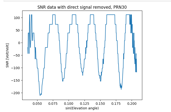
In recent years, GNSS interferometric reflectometry has been an upcoming technique to measure water levels, and potentially provides a low-cost alternative to more traditional in situ gauges. GNSS signals also reflect from water surfaces and these reflections interfere with the direct line-of-sight signals as received in the antenna’s. For positioning purposes, the reflected signals are considered a nuisance, and creates oscillations in the signal to noise ratio. However, the same oscillations can also be processed to retrieve the height of the GNSS antenna above the reflecting surface.
Commercial products such as raspberries pi’s in combination with GNSS boards, create opportunities to produce low cost GNSS interferometric water level gauges. However, currently, data needs to be processed off-site and requires expert knowledge and tools. Furthermore, downloading data files can become problem in areas with low-bandwidth connectivity.
For this topic, an alternative processing chain will be developed which runs on board of the receiver, resulting in lower band-width need and direct water level estimates from the receiver. The receiver will be instructed to regularly generate messages which can be published on a central (MQTT) server, which opens up the possibility to scale up both the amount of receivers and also the uptake of the information by other data users.
In this topic, you will produce an algorithm which generates, from GNSS signal to noise ratio, water level estimates accompanied by uncertainties. This can be initially developed using Python but optionally can also be ported to C for better efficiency allowing it to run on low-power embedded devices such as the Actinius Icarus board.
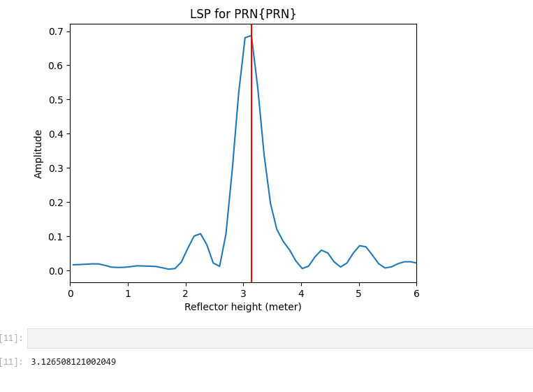
One technique to create continuous water level estimates is to use a Kalman filter, which produces smoothly varying estimates by updating the previous estimate once new data becomes available. The height estimates themselves can be extracted from sereis of signal to noise ratio data using Lomb-Scargle periodograms.
The selection of GNSS reflections requires knowledge about the orientation of the water body relative to the receivers antenna. The student will therefore incorporate the design of azimuth elevation masks from analyzing reflections falling within a GIS polygon representing the water body of interest. The mask can consequently be used to only retain the most useful GNSS reflections in the processing.
- Karegar, M., Kusche, J., Geremia-Nievinski, F., Larson, K., 2021. Raspberry Pi Reflector (RPR): a low-cost water-level monitoring system based on GNSS Interferometric Reflectometry 2021, G51A-11.
- Roesler, C., Larson, K.M., 2018. Software tools for GNSS interferometric reflectometry (GNSS-IR). GPS Solut 22, 80. https://doi.org/10.1007/s10291-018-0744-8
- Chew, C., n.d. Soil Moisture Remote Sensing using GPS-Interferometric Reflectometry 175.
- RIVFLECT ESA project flyer (https://surfdrive.surf.nl/files/index.php/s/z5FSLiHCwKeQ4bJ)
Water level monitoring is a crucial activity for many waterboards and (governmental) organizations. Gauging networks can not be arbitrarily dense, and the deployment and maintenance of devices most be cost-effective and understandable for the target users. In particular in Africa, accessibility, vandalism, and geopolitical sensitivity are relevant factors which come into play.
This topic can therefore be adapted to a Spatial engineering by focusing more on the added value and design of potential monitoring networks. Relevant questions, are for example, what would be conditions for optimal functioning of such a network and how can the uptake of the information to end users be enabled.