Monitoring spatial heterogeneity of restored nature at high resolution with Planet data
The topic is also suitable for GEM students in track 1 – GEM for Urban-Rural Interactions and track 3 – GEM for Ecosystems & Natural Resources.
Suggested electives: Elective Spatial Analyses of Ecosystem Services | Image analysis | optional: Advanced image analysis
Fieldwork in Buurserzand is possible, also stakeholders of the area can be included.
This topic is part of the ITC Space4Restoration project, which aims to develop remote sensing tools to follow nature restoration and see if management and policy measures have the desired effect. This work would focus on one of two sites/projects of the project. The first is the Buurserzand, close to Enschede, with heather, shrubs, sandy dunes and patches of forest. Part of the area was only recently converted to nature area, after being farmland for a long time. The second is in Lebanon, where degraded lands are reforested with native tree species. In both projects, high spatial resolution remote sensing datasets obtained by Planet can help us in assessing the success by looking at spatial heterogeneity patterns within the restoration sites. MSc students will be able to choose one of these two sites/projects their research. In case of Buurserzand, field data could be acquired in spring/summer as well in consultation with the owner (Natuurmonumenten) and staff of the Space4Restoration project. In case of Lebanon field data from the local organisation involved in tree planting can be used.
To turn the tide of biodiversity losses, restoration interventions are implemented all over the world. With these interventions people aim to improve biodiversity and the crucial benefits it provides to people. Monitoring and evaluation of these intervention sites is key to learn about the effectiveness of restoration practices. Accurate observations on the ecological state, e.g. species composition and ecological structures, is key in any monitoring process.
One of the indicators for restoration is spatial heterogeneity, because an area which is left for nature to (re-)develop will usually show an increase in spatial diversity, with patches of plants and different (micro-) habitats developing. Therefore, monitoring spatial heterogeneity can help in identifying if or where restoration interventions have been successful. Spatial heterogeneity can also be an explicit goal in nature restoration projects, e.g., to increase the number of available habitats and species richness.
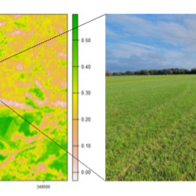
In this MSc topic, PlanetScope data of approximately 3m spatial resolution will be used to monitor spatial heterogeneity patterns within restoration projects. In this research, you will have the opportunity to address one of these two questions: 1) can PlanetScope time series be used to monitor restoration in the Buurserzand Natura 2000 area and do spatial and/or temporal patterns of remotely sensed heterogeneity correspond to changes in plant communities detected on the ground? or 2) can PlanetScope time series be used to improve early-stage reforestation monitoring in Lebanon compared to lower spatial resolution Sentinel-2 data.
The first question relates to mapping of plant communities which are related to the management goals of the Buurserzand Natura-2000 area. With management interventions such as topsoil removal and alteration of the ground water table, the management aims to promote certain species composition (plant communities) and ecological structures. Mapping these communities and structures can show whether management interventions had the desired effect.
The second question could assist in the operational monitoring of reforestation efforts over large areas. Monitoring the success of reforestation now often consists of field visits and counts of seedling survival rates. PlanetScope data provides the opportunity to automate this monitoring over larger spatial and temporal scales, while still maintaining spatially explicit information.
For spatial engineering, the topic can be modified in two ways:
- Include a modelling component to describe the development of spatial heterogeneity to be combined with the remote sensing data.
- Include stakeholder views on development of spatial heterogeneity. This is an option for Buurserzand, where stakeholders can identified and approached, but less so for Lebanon.